- Where it earns its place
- Where to be careful
- Typical sensors

Aerhub Advisory for utilities and aerial operators
Aerial programs, planned by people who fly them.
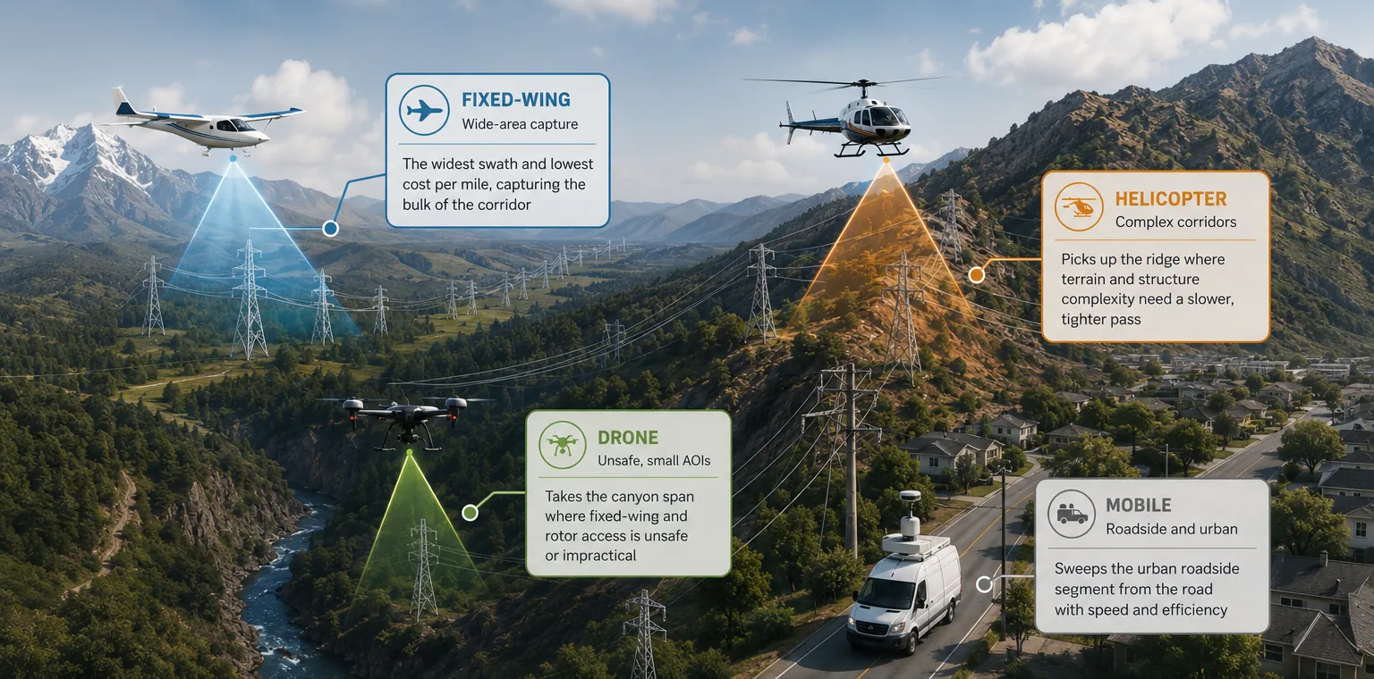
We help electric utilities and aerial service providers choose the right platforms, validate the data they collect, and grow programs that hold up in the field, across fixed wing, helicopter, drone, and mobile capture.
Gyro-stabilized sensor pod on fixed wing patrol
Platform estimator
A simplified version of our Platform Planning Tool, which we run on client KMZ and shapefile data.
Project type
Linear capture along a line, flown as one continuous pass.
Data density
High density tightens the spacing between flight lines.
Terrain
Adjust rate assumptions
Rates are for standard density. High density adds 60% to fixed wing and 30% to helicopter.
Modeled corridor, conductor colored by assigned platform300 mi
Drag to rotate
Modeled plan cost
$0
Helicopter only
$0
Difference
$0
Rates are illustrative planning figures, not a quote. Real plans score every circuit on regulatory, environmental, efficiency, and cost factors.
Fortune 500 utility programsAdvisory and planning for large T&D and vegetation programs
30+ years combinedFlight operations, software, and geospatial experience
Four capture platformsFixed wing, helicopter, drones, and mobile, with no single-platform bias
Federal readyRegistered in SAM.gov for prime and teaming work
Aviation and geospatial intelligence
Aerial data becomes operational intelligence.
Aerhub advises the plans and workflows behind the flight line, connecting aerial imagery, inspection data, and decision-ready outputs across programs and operations.
Select a sensor footprint in the scene or a platform photo to see where each one fits, then load it into the estimator.
Aerhub Advisory
Trusted Advisors for Smarter, Safer Aerial Operations
Aerhub Advisory is the strategic advisory practice for aviation operators and businesses looking to scale, modernize, or strengthen their operations. Unlike generic consultancies, we are aviation-native operators who have built and led aviation businesses ourselves, bringing firsthand understanding of regulatory complexity, safety culture, operational realities, and sustainable growth.
Who we work with
Electric utilities and cooperatives
Plan the capture season, pick platforms circuit by circuit, score line criticality, and hold vendors to spec on LiDAR and imagery deliverables.
Aerial service providers
Drone, helicopter, fixed wing, and LiDAR operators who want program design, stronger operations, or business development representation into utility markets.
Engineering and survey firms
Teaming on RFPs where aerial acquisition, QA/QC, and multi-vendor project management need an aviation-native lead.
Public agencies
Federal and state programs that need aerial acquisition strategy or a qualified teaming partner for infrastructure and land work.
Aerial program strategy and design
For organizations standing up, formalizing, or scaling a manned, unmanned, or blended aerial program.
- Program standup and operating model
- SOPs, policy, and safety framework
- Regulatory alignment for manned and drone operations
- Platform and sensor field evaluations
- Contractor and team structure
Data products and integrations
For programs whose product is the data they collect, from acquisition plan to decision-ready output.
- Corridor and wide-area acquisition planning
- LiDAR and imagery QA/QC against spec
- GIS integration and data pipelines
- Custom tools: Priority Matrix and Platform Planning Tool
Business development and project support
For aerial providers growing into new markets, and for clients who need one accountable lead across vendors.
- BD representation and partnership sourcing
- RFP pursuit, teaming, and proposal support
- Prime project management for multi-vendor capture
- Federal opportunity teaming
- Staff augmentation
The Aerhub toolkit
We bring working tools, not just recommendations.
Every engagement can put these to work on your own data. Each was built for a real utility problem and refined in the field.
Priority Matrix
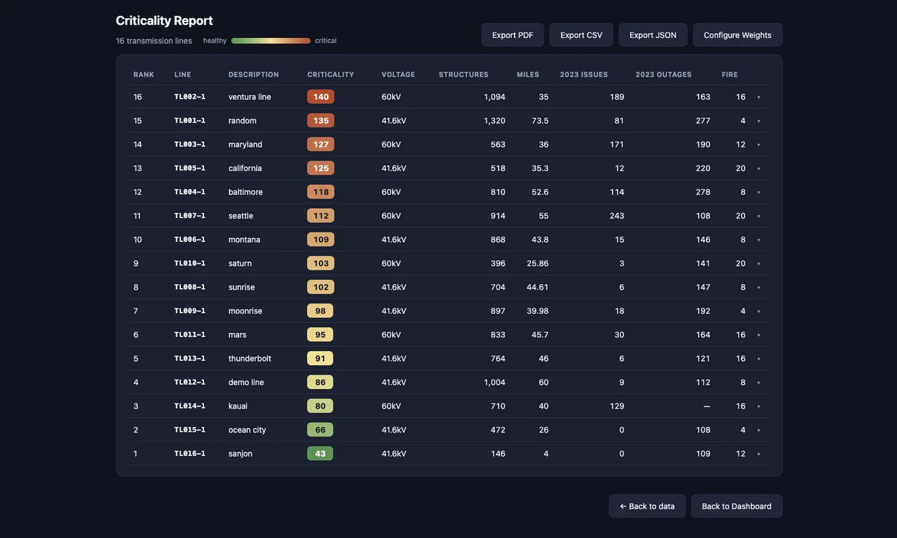
Configurable scoring that ranks transmission lines and work by criticality, so inspection and maintenance dollars follow risk. Upload line data, review it on the map, tune the weights, and generate the report.
Workflow
- Upload line data
- Review results on the map
- Adjust weights and re-score
- Generate the report
Built for
- Reliability and asset management engineers
- Vegetation management planners
- Capital planning teams
Outputs
- Ranked list with criticality scores
- PDF report for leadership
- CSV and JSON for your GIS
Capture review and QA/QC
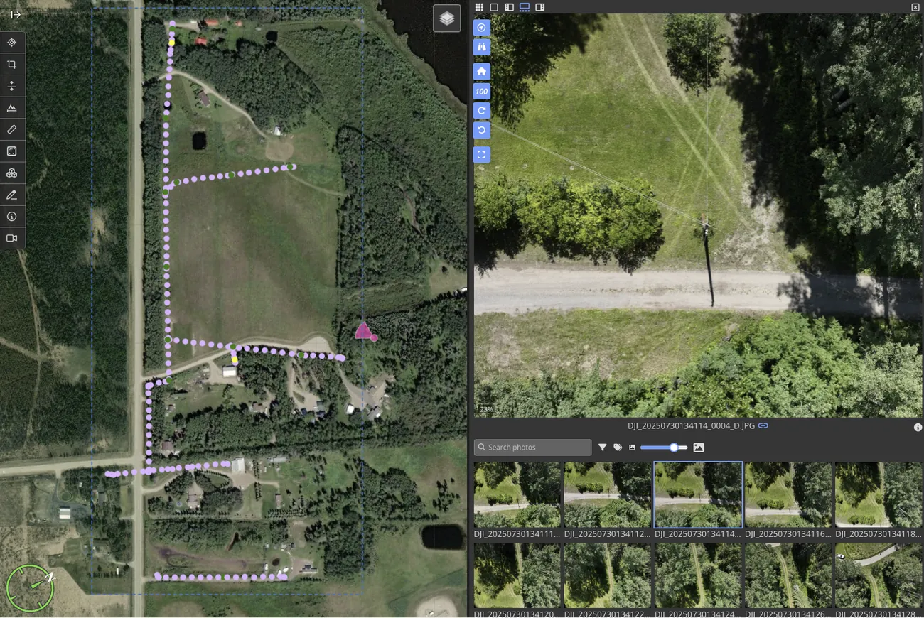
An independent check between your acquisition vendor and your engineers. We confirm the flight covered what it should, the imagery and point clouds meet spec, and every gap is found before design work starts.
We check
- Coverage and gaps along the line
- Point density, accuracy, and classification
- Image quality and overlap
Against
- Your utility specification
- Survey control
- Engineering deliverable requirements, including PLS-CADD
You get
- Acceptance findings by block
- Clear corrective actions for the vendor
Platform Planning Tool
Upload your circuits or survey areas and get a defensible platform assignment for each one, with the blended plan's cost compared against a single-platform approach. Planners can override any assignment while the model's own pick stays visible.
You provide
- KMZ, KML, zipped shapefile, or GeoJSON
- Your attribute columns, mapped in the tool
- Project type: corridor or wide area
It scores
- Regulatory, environmental, efficiency, and cost factors
- Hard exclusions where a platform can't fly the work
- Fixed wing, helicopter, drone, and mobile per circuit or area
You get
- Mileage and area allocation by platform
- Cost model against single-platform baselines
- CSV, GeoJSON, and JSON exports
Field evaluations
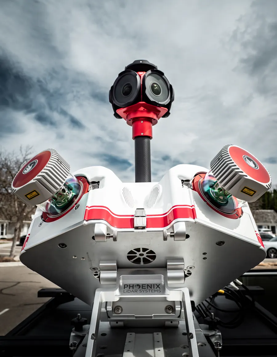
Before you commit a program budget, we test candidate platforms and sensors on your lines and compare them on the outputs you actually need.
Configurations
- Gyro-stabilized sensors on fixed wing for visual line patrol
- Helicopter conductor imaging
- Drone and mobile LiDAR capture
Compared on
- Detection quality
- Miles per day and cost per mile
- Safety and regulatory fit
You get
- A side-by-side scorecard
- A platform recommendation you can defend
Priority Matrix, live
Change the weights. Watch the priorities move.
Sixteen sample transmission lines from the Priority Matrix demo set. Every utility weighs risk differently, and the Priority Matrix lets your engineers decide what matters most.
Weights
0 ignores a factor; 5 makes it dominant.
Most critical first. Scores run 0–150. One line has no 2023 outage record, so that factor counts as zero for it.
How we work
Structured to fit the shape of the work.
Discovery call
Thirty minutes on your program, your data, and the decision in front of you.
Scope
A written scope with deliverables, timeline, and price agreed before work starts.
Deliver
We run the analysis on your data and work alongside your team, not from a distance.
Support
Optional ongoing advisory as the program moves from plan to flight season.
Scoped engagements
Defined deliverables, fixed terms
For platform studies, program standup, data QA/QC, and go-to-market plans.
- Platform planning assessment on your circuits or areas
- Priority Matrix pilot
- Aerial program review
Retainer and BD representation
Ongoing partnership and deal flow
For clients who want a continuous advisory relationship or commercial representation, with optional finder's fee terms on sourced work.
- Monthly advisory access
- Market and partner introductions
- RFP and teaming support
Practice team
Advisors who have built what we advise on.
Cory Vinger
CEO and practice lead
Commercial pilot and aviation technology executive with a University of North Dakota aeronautics background and operating experience across drones, helicopters, and fixed wing. Leads strategy, business development, and the GIS and software behind Aerhub's tools.
Mitchell Banks
Contractor, operations and programs
10+ years in aviation operations, including building and leading aerial operations teams for Fortune 500 programs nationwide.
Dennis Kalaygian
Contractor, technology and platforms
10+ years in software engineering and infrastructure. Advises on platform architecture, AWS infrastructure, and aerial data system design.
Partner network
Capture, processing, and AI
Vetted partners across fixed wing, helicopter, drones, data processing, and AI. We disclose partner relationships in every proposal.
Line of Sight: a utility aerial field day
A one-day event in North Dakota and Minnesota with live aerial technology demonstrations for utility and cooperative decision-makers.
Start a conversation
Book a discovery call.
Tell us what you're working on. We'll reply within one business day with times for a 30-minute call.
- support@aerhub.com
- Company
- Aerhub, Inc., Arizona
- Serving
- Utilities and aerial operators nationwide
Discovery call request
Attached